|
|
 As Florida, Texas and other areas slammed by devastating hurricanes Harvey and Maria continue to clean up, and experts study the intensity of Atlantic hurricanes, many in the local real estate community are examining the potential impact of a powerful hurricane could have in Massachusetts.
Major hurricanes are rare here, in large part because Massachusetts is so far north, but the region is far from impervious. According to the Massachusetts Executive Office of Energy and Environmental Affairs, New England has only had three Category 3 hurricanes (5 is the highest), one in 1938 and two in 1954. To put this in context, since 1938, Florida has endured 10 Category 3s, eight Category 4s, and one Category 5, Hurricane Andrew in 1992. For Massachusetts, the 1938 storm was the most destructive, with wind gusts up to 186 miles per hour.
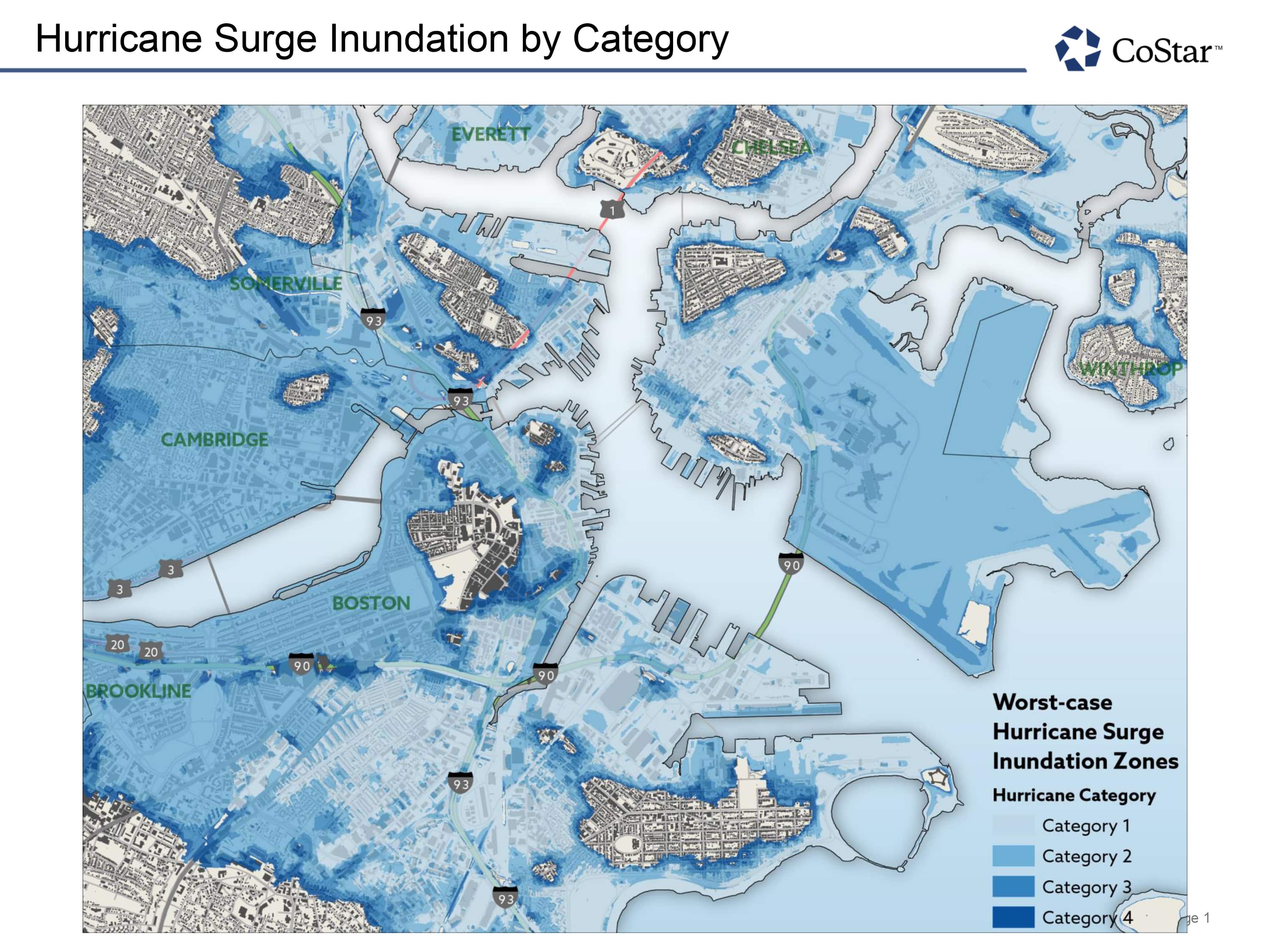
Using FEMA tools, which include Flood Harvard Layers available in a Geographic Information Systems (GIS) application – and focusing on commercial real estate in Greater Boston – we mapped the potential impact a Category 3 or 4 storm could have here.
The corresponding map shows flooding by hurricanes in categories 1 through 4, and demonstrates that even in a Category 2, huge swaths of Boston and Cambridge would be under water. What’s more, in other centers of commercial real estate – Brookline, Somerville and Quincy – the impact is calamitous. Under this scenario, perhaps the only major commercial real estate node not to be hit is Burlington. Waltham, nine miles to the south, would likely flood from the surge in the Charles River.
The data also shows that Logan Airport would be entirely submerged by the storm surge. Boston’s medical centers, at Mass General Hospital and the Longwood Medical Area, are also at high risk of severe flooding.
Next, we looked at the percentage of commercial properties most likely to be impacted by a Category 3 hurricane in the four Massachusetts cities/towns with the most commercial property within the flood zone. We found slightly more than 10 percent of the buildings would be at risk from a Category 3 storm. While one might think that number is small, it’s important to remember the areas 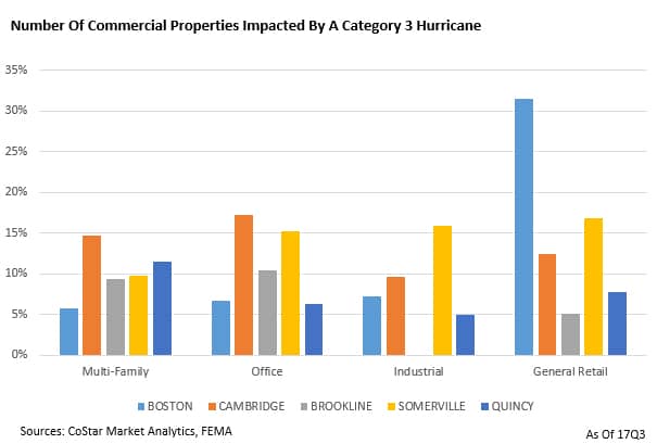 most impacted are those where the biggest buildings are located, so the total square footage impacted would be significantly greater. While it’s difficult to know how much of a building with severe flooding goes off line, if the whole building is considered it’s a very big impact in these areas. Brookline, for example, would see 65 percent of its institutional apartment inventory and 31 percent of its office space impacted by a Category 3 hurricane.
As those areas most affected by hurricanes Harvey and Irma begin their rebuilding process, there is concern for how they can best plan for future storms and storm surges. For property owners in Massachusetts communities facing the ocean and along rivers and streams, threats from a Category 2 or Category 3 storm need to be addressed now. That means assessing emergency preparedness and insurance coverage well in advance of the next hurricane season.
Mark Hickey is a commercial real estate consultant for CoStar Portfolio Strategy. Patrick McCafferty is a GIS analyst for CoStar.