|
| 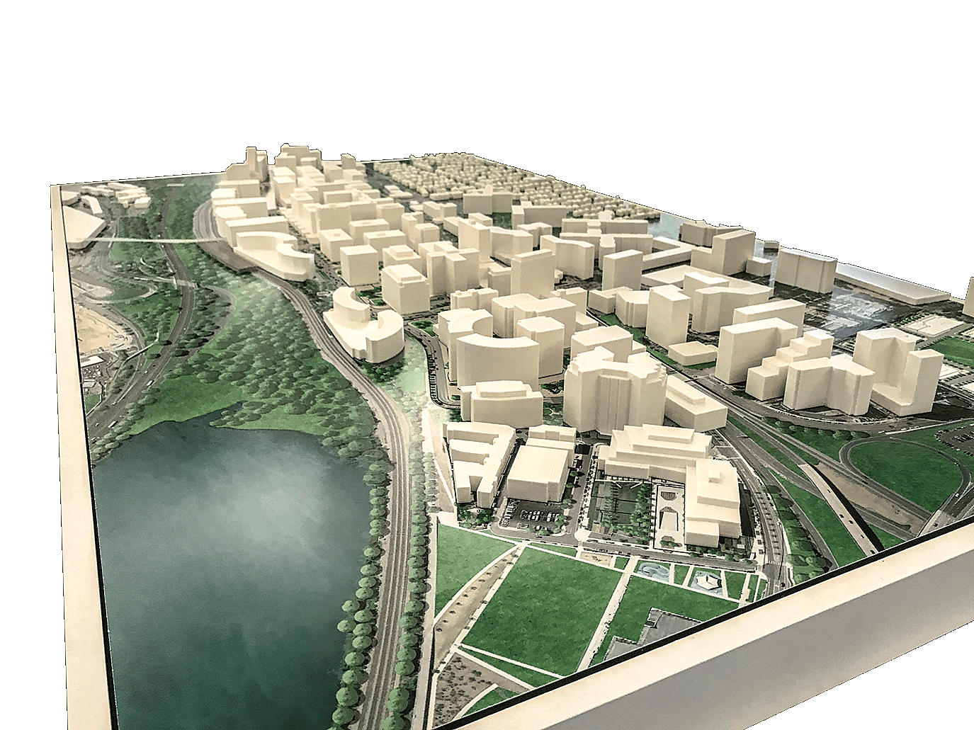
A small-scale model enables designers to swap landscapes and buildings in and out to make new combinations come to life in real time. Photo courtesy of Elkus Manfredi Architects
Real estate development has always been about the measurement and analysis of land and the assets upon it. Through many centuries, the quest has always been to provide better measurement and better analysis to enable better decisions.
Today, the leading edge of that quest lies in the mining of the vast amount of data that already exists for any given asset. Raw data, when harnessed and visualized during the design process, can provide insight and create tremendous value. From simulating and analyzing miles of urban context down to a single square meter of community open space, 3D visualization and modeling are revolutionizing commercial site analysis and design techniques to deliver better developments and better buildings.
Our experience with National Landing, a development project currently underway in Arlington, Virginia, shows the benefits of these processes. Working on the vision for National Landing alongside JBG SMITH, a real estate investment trust based in Bethesda, Maryland, the team at Elkus Manfredi Architects is using 3D visualization and modeling tools to maximize land value as well as environmental stewardship for buildings and benefits for the community.
Designers are utilizing data already existing in the public domain to develop a series of 3D studies to accompany the many insights of experience and anecdotal analysis and inform decision making. These studies are helping the team gain a new perspective on urban planning for National Landing and its ramifications for the environment, economics and equity.

This rendering of the open space surrounding Dining in the Park at National Landing was created to work hand-in-hand with a 3D model of the site, allowing for quick analysis of different design solutions. Image courtesy of Elkus Manfredi Architects
Three Questions Shape a Development
During strategy meetings for the permitting, entitlement and master planning phase of the project, three questions emerged:
- Can we compare our master plan to other cities in terms of density and height?
- What would it take to optimize a building design to meet the criteria of the city design guidelines and also our own building metrics?
- Is it possible to make an interactive physical model for our design meetings?
To answer the first question, the team developed a height density map of the existing built conditions within the National Landing site. By creating a digital model of the proposed master plan, the team was able to quickly explore options, comparing a proposed design solution with other cities of interest. Stakeholders and community members could see similarities and differences in new ways, while the map itself gave a new visual identity to National Landing, unlocking the power to see clusters, patterns, adjacencies and even negative space.
JBG SMITH Executive Vice President Evan Regan-Levine commented that this visual representation of the data “literally sprang from my mind’s eye!”
The next 3D tool answers the second question. Arlington County’s design guidelines regulating direct sunlight in open spaces are thorough and specific. Throughout the plan, there are many public spaces and parks that require this attention to detail.
The team developed an algorithm to posit several different building forms that would maintain 55 percent direct sunlight in the open space, as well as a solar heat map of Center Park, located in the heart of National Landing. The surrounding buildings define the open space and spill into the park, creating a rich place for the community to gather. Coloration indicates how much sunlight is directed at Center Park on a chosen day for a duration of time. Looking even closer at the intervals of time, the team has been able to home in on the sunlight values needed to ensure guideline compliance.

John H. Martin
Digital Meets Physical
Answering the third question, another 3D tool creates a more accurate spatial relationship than digital drawings alone.
Stakeholders are able to study proportion, form and newly-created relationships between environments and buildings on a tabletop physical model that works much like a finely crafted chess board. Using moveable, interchangeable pieces and parts for every prospective site, the team is able to swap landscapes and buildings in and out to make new combinations come to life in real time. These small-scale models have proven to be illuminating for public and community design review presentations.
Researching and implementing new tools and technologies that can be implemented as part of the design process are ongoing pursuits. Three-dimensional data visualization and physical modeling allow for a nimble process, including quick analysis of ideas as they are developed. Combining data that already exists in the public domain with specialized 3D modeling applications aids developers, designers and communities in making more informed and objective decisions about places we live, work and play.
John H. Martin is a principal at Elkus Manfredi Architects and fellow of the American Institute of Architects.